History of Roads on Ancient Roman
Roman Roads Today – Italy – France – UK. – Spain
The history of ancient Roman roads begins with the founding of Rome in 753 BCE. The Romans recognized the importance of building roads for both military and economic purposes. The first roads were simple paths made of dirt and gravel. Over time, the Romans improved their roads by paving them with stones, and later with bricks and concrete.

One of the most famous Roman roads is the Appian Way, which was built in 312 BCE and connected Rome to the southern city of Capua. The road was named after the Roman statesman Appius Claudius Caecus, who oversaw its construction. The Appian Way was also extended to the port city of Brindisi and became an important trade route for the Roman Empire.
The Roman road network was expansive, covering over 250,000 miles throughout the empire. Roads were built to connect cities and military installations, and they played a crucial role in the expansion and maintenance of the Roman Empire. In addition to the Appian Way, other famous Roman roads include the Via Flaminia, which connected Rome to the northern city of Rimini, and the Via Egnatia, which connected Rome to Constantinople (modern-day Istanbul).

Roman roads were known for their durability and engineering feats. They were built with a slight curve to allow for drainage, and they were elevated in the middle to allow for better water runoff. The roads were also lined with curbstones to prevent erosion and wear and tear. In addition, Roman engineers built bridges, tunnels, and viaducts to overcome obstacles such as mountains and rivers.
Today, many Roman roads still exist, and some are still in use as major thoroughfares in modern Europe. The legacy of the Roman road network is a testament to the ingenuity and engineering prowess of the ancient Romans.

The main roads of ancient Rome were
Via Appia, the Via Flaminia, the Via Aurelia, the Via Cassia, the Via Salaria, the Via Valeria, the Via Latina, the Via Nomentana, the Via Tiburtina, the Via Labicana, the Via Praenestina, Via Ardeatina, Via Ostiense, Via Portuense, Via Prenestina, Via Collatina, Via Anicia, Via Campania, Via Laurentina, Via Severiana, Via Trajana, Via Popilia, Via Egnatia,, the Via Flavia, Via Augusta, Via Agrippa

Via Claudia Augusta, the Via Domitia , the Via Julia Augusta, the Via Postumia, the Via Aemilia, the Via Caecilia, the Via Claudia, the Via Clodia, the Via Caelimontana, the Via Lata, the Via Nova, the Via Praetoria, Via Domitiana, Via Recta, the Via Triumphalis, the Via Vittoriana, the Via Appia Antica, the Via Ardeatina, the Via Latina, the Via Ostiense, the Via Prenestina, the Via Salaria,
Samsung Store: Galaxy Z Fold4 Series

What is the history of the Via Appia?
The Via Appia, also known as the Appian Way, was one of the most famous and important ancient Roman roads. It was named after Appius Claudius Caecus, a Roman censor who oversaw its construction in 312 BCE.
The Via Appia began in Rome and originally extended southeast to the coastal city of Capua, a distance of approximately 120 miles. Later extensions connected it to Brundisium (modern-day Brindisi) on the Adriatic coast, a total distance of over 350 miles. The road was used primarily for military purposes, allowing troops and supplies to be quickly transported to the south of Italy and beyond.
The construction of the Via Appia was a major engineering feat of the time. The road was built with a foundation of crushed stones, followed by a layer of gravel, and then covered with large, flat paving stones. The road was also built with a slight curve and a raised center to allow for drainage, and was lined with drainage ditches on either side. This design helped to prevent the road from becoming waterlogged or eroded during heavy rains.

Along the Via Appia, the Romans built several important structures, including bridges, aqueducts, and tombs. One of the most famous is the Tomb of Caecilia Metella, which was built in the 1st century BCE and still stands today as a well-preserved example of Roman funerary architecture.
During the decline of the Roman Empire, the Via Appia fell into disrepair and was eventually abandoned. However, the road’s legacy lived on, and it became a symbol of the Roman Empire’s engineering prowess and military might. Today, parts of the Via Appia are still visible and can be visited, including the Tomb of Caecilia Metella and sections of the road near Rome.

What is the history of the Via Domitia?
The Via Domitia was an ancient Roman road built in 118 BCE by the Roman general and consul, Gnaeus Domitius Ahenobarbus. It was the first Roman road to be built in Gaul (modern-day France) and connected the city of Narbo Martius (modern-day Narbonne) on the Mediterranean coast to the Pyrenees Mountains and ultimately to Hispania (modern-day Spain).
- Tourism in Ancient Greece and Rome")
The Via Domitia was a key strategic and economic route for the Roman Empire, providing access to the rich resources of Hispania and serving as a military road for the Roman legions. The road was approximately 460 kilometers (285 miles) long and was constructed using a combination of stone paving, gravel, and earthwork. Along the way, the Romans built bridges, tunnels, and viaducts to overcome obstacles such as rivers and mountains.

The Via Domitia played an important role in the Romanization of Gaul, as it facilitated the movement of people, goods, and ideas between Rome and the Gallic tribes. As the Roman Empire expanded, the Via Domitia was extended further north into Gaul, connecting to other major cities such as Nimes, Arles, and Lyon.
Despite its importance, the Via Domitia fell into disrepair during the Middle Ages and many sections of the road were destroyed or lost. However, efforts have been made in recent years to restore and preserve the remaining sections of the road, and it is now a popular tourist destination for those interested in Roman history and architecture.
What is the history of Via Egnatia?
The Via Egnatia was a major ancient Roman road that ran from the Adriatic Sea to Constantinople (modern-day Istanbul) in the east. It was constructed during the 2nd century BCE and was named after the Roman general and proconsul Gnaeus Egnatius.
The Via Egnatia was built to connect the Roman provinces of Macedonia and Thrace, and was a vital trade and military route for the Roman Empire. The road extended over 1,100 kilometers (680 miles) and passed through some of the most important cities of the time, including Apollonia, Thessaloniki, and Philippi.
The road was constructed using a combination of stone paving, gravel, and earthwork, and included several bridges and tunnels to overcome obstacles such as rivers and mountains. The road was also designed with a slight curve and a raised center to allow for drainage and prevent erosion.

Along the Via Egnatia, the Romans built several important structures, including bridges, aqueducts, and fortified towns. The road played a significant role in the Romanization of the Balkans, as it facilitated the movement of people, goods, and ideas between the Roman Empire and the local populations.
During the decline of the Roman Empire, the Via Egnatia, fell into disrepair and was largely abandoned. However, parts of the road were later used by the Byzantine Empire, and many sections of the road have been rediscovered and preserved in modern times. Today, the Via Egnatia is a popular tourist destination, and visitors can explore many of the road’s historic sites and landmarks.

The Via Agrippa was an ancient Roman road that connected Lugdunum (modern-day Lyon) in Gaul (modern-day France) to the city of Boulogne-sur-Mer on the English Channel. It was built during the reign of Augustus Caesar in the 1st century BCE and named after his general and son-in-law, Marcus Vipsanius Agrippa.
The Via Agrippa was a key strategic and economic route for the Roman Empire, providing access to the rich resources of Gaul and facilitating the movement of people, goods, and ideas between Rome and the northern provinces. The road was approximately 1,500 kilometers (930 miles) long and was constructed using a combination of stone paving, gravel, and earthwork.

Along the way, the Romans built several important structures, including bridges, tunnels, and fortified towns. The road also served as a military road for the Roman legions, and was used to transport troops and supplies during the conquest of Gaul and the Roman campaigns in Britain.
During the decline of the Roman Empire, the Via Agrippa fell into disrepair and was largely abandoned. However, parts of the road were later used by the medieval French monarchs and many sections of the road have been rediscovered and preserved in modern times.
Today, the Via Agrippa is a popular tourist destination for those interested in Roman history and architecture. Visitors can explore many of the road’s historic sites and landmarks, including the Roman amphitheater in Lyon and the Gallo-Roman town of Saint-Romain-en-Gal.

What is the history of Triumphalis?
Via Triumphalis is a Latin term that refers to a triumphal road, which was a ceremonial route used in ancient Rome for the triumphal processions of victorious generals and emperors. These triumphal processions were highly ritualized and involved the display of captured treasures, spoils of war, and prisoners of war.
The Via Triumphalis was a specific route that started at the Campus Martius and passed through several significant landmarks in Rome, including the Circus Maximus, the Colosseum, and the Arch of Titus. The procession would then end at the Temple of Jupiter on the Capitoline Hill.
The route of the Via Triumphalis was intentionally designed to showcase the power and glory of Rome and its rulers. The processions served as a reminder to the citizens of Rome of the might and success of the empire, and they were often accompanied by public spectacles, such as gladiator games and theatrical performances.
Today, the term Via Triumphalis is still used to describe ceremonial routes in modern contexts, such as the parade route for military victory celebrations or other grand processions.
Ancient Roman Roads in Italy
- Via Appia – south of Porta San Sebastiano (Rome).Via Aemilia (-187 Marcus Aemilius Lepidus) from Rimini (Ariminum), to the end of Via Flaminia,
- Via Cesena, Bologna towards Piacenza (Placentia) and Milan, auj. SS 9.
- Via Aemilia Scaura (-109 Marcus Aemilius Scaurus) extension of Via Aurelia, from Pisa, along the Ligurian coast through Genoa towards Vado Ligure (Vada Sabatia), from
- Via Julia Augusta, towards Piacenza (Placentia).
- Via Amerina from Rome towards Amelia (Ameria) and Perugia.
- Via Annia (153 consul Titus Annius Luscus) from the gate of Adria, through Padua towards Aquileia.
- Via Appia Antica (-312 the oldest Roman road, Appius Claudius Caecus) from Rome via Albano, Terracina, Capua, Benevento (Beneventum), Venosa and Taranto (Tarantum) towards Brindisi (Brundisium, -264) in Apulie, auj. approx. SS 7.
- Via Ardeatina from Rome via Falcognana towards Ardea (near Aprilia).

- Via Aurelia (-241 Gaius Aurelius Cotta) from Rome via Orbetello (Cosa), Pisa towards Lucca, later via Genoa, Savona towards Ventimiglia and towards la Gaule, auj. SS 1.
- Via Campania along the Tibre, parallel to the Via Portuense, towards Saline Veienti.
- Via Casilina from Rome via Anagni, Frosinone towards Casilinum, near Cassino.
- Via Cassia (-171) from Rome (a branch of the Via Flaminia) via Sutri, Viterbo via Étrurie, and via Arezzo (Aretium) towards Firenze (Florentia), and further, via Pistoia towards Lucca and Pisa (joining the Via Aurelia).
- Via Caecilia (-142 Lucius Caecilius Metellus Calvus, or -117 Lucius Caecilius Metellus Diadematus) branch of the Via Salaria via Amiternum (near La Aquila), crossing the Central Apennines via the Passo de la Capanelle and heading via Atri (Hatria) and Teramo towards Giulianova (Castrum Novum) towards the Adriatic coast.
- Via Clodia ou Via Claudia (-225) from Rome (branch of Via Cassia) through Bracciano and Veiano, joining Via Cassia again.
- Via Collatina Antica from Rome, south of the Aniene river, towards Collatie near Palestrina (Praenesta).
What is Via Domitiana?
(-95 Domitien) from Terracina via Pozzuoli (Puteoli) towards Portus Iulius in the Bay of Naples, then via Napoli (Neapolis) towards Reggio (Rhegium).
Via Domitiana was an ancient Roman road that connected the city of Naples (Neapolis) to the important port of Puteoli (modern-day Pozzuoli), both located in the Campania region of Italy. The road was named after the Roman Emperor Domitian, who ordered its construction during his reign (81-96 AD) to improve the communication and transport between Naples and Puteoli.
Via Domitiana was a crucial road for the transportation of goods and people in the Roman Empire, as Puteoli was an important hub for trade with the eastern Mediterranean. The road was approximately 28 kilometers long and passed through the Phlegraean Fields, a volcanic area in the Bay of Naples.
Today, only a few sections of Via Domitiana are still visible, and some parts have been incorporated into modern roads. However, several archaeological sites, such as the Roman amphitheater of Pozzuoli and the Flavian Palace in Baiae, can still be visited along the road’s original route.

- Via Empolitana from Tivoli (Tibur) to Subiaco.
- Via Farnesiana branch of Via Aurelia, towards Farnese (west of Lake Bolsena).
- Via Flaminia (-220 Gaius Flaminius) from Rome via Narni (Narnia), towards Fano (Fanum Fortunae) or Rimini (Ariminum), auj. SS 3.
- Via Flaminia Nuova, more recent variant of the Via Flaminia, through Spoleto (Spoletum).
- Via Flaminia Minor or Via Flaminia militaris (-187) from Arezzo (Arretium) to Rimini (Ariminum).
- Via Gallica from Verona (branch of the Via Postumia) via Brescia, Bergamo towards Milano (Mediolanum).
- Via Julia Augusta (I) (-13 Auguste) Extension of the Via Aurelia and the Via Postumia, from Genoa via Vado Ligure (Vada Sabatia), along the Ligurian coast via Albenga (Albigaunum) and Ventimiglia (Albintimilium), then through the maritime Alps towards Arles (Arelate) or Tarascon, in Gaule (junction with Via Domitia ).
- Via Julia Augusta (II), another « Via Julia Augusta », from Aquileia to the north via Zúglio (Iulium Carnicum) and via the Plöckenpass towards the Drautal, splits off at
- Irschen (castrum Ursen) and leads via Aguntum (near Lienz) and Innichen (Littamum) to Veldidena (Wilten/Innsbruck), or via Teurnia (near Spittal) and Virunum (near Klagenfurt) to Iuvavum (Salzburg).
- Via Labicana in Rome, from Via Latina, through Labicum towards Via Praenestina.
- Via Latina from Rome, north of the Albains mountains, through Anagni, Ferentinum, Frosinone (Frusino) and Liri, towards Capua (junction with the Via Appia).

Where is the Via Laurentina?
Via Laurentina was an ancient Roman road that connected the city of Rome to the coastal town of Laurentum, located in what is now modern-day Lazio region of Italy. The road was named after Laurentum, an important port town during the Roman Republic era.
Via Laurentina was constructed during the 4th century BC, and it was one of the earliest and most important roads leading out of Rome. It was used primarily for the transportation of agricultural products, such as grain, from the fertile land around the Tiber River to the port of Laurentum, where the goods could be shipped to other parts of Italy and the Mediterranean.
The road was approximately 12 miles long and passed through the countryside, with many farms and small settlements located along its route. In the Imperial era, several luxurious villas were built along the Via Laurentina, including the Villa of Maxentius, which was later converted into a Christian basilica.
Today, only a few sections of Via Laurentina are still visible, and much of the original road has been incorporated into modern streets and highways. However, visitors to Rome can still see some of the road’s ancient ruins, such as the remains of the Villa of Maxentius in the Appian Way Regional Park.
- Via Nomentana from Rome to Mentana (Nomentum), (formerly Via Ficulensis towards Ficulea).
- Via Ostiense from Rome towards Ostia (port of Rome) south of the Tibre.
- Via Palombarese, medieval name of the Via Nomentana towards Polombara Sabina.
- Via Pompea (-210), Sicilian belt.
- Via Popilia or Via Capua-Rhegium (-132 consul Publio Popillio Lenas) from Capua, through Nocera (Nuceria), Morano (Moranum), Cosenza (Cosentia), Vibo (Valentia), towards Reggio Calabria (Rhegium).
- Via Popilia-Annia (-132) from Rimini to Aquileia.
- Via Portuense (Claude) from Rome to the port of Portus Augusti, north of the Tibre (auj. Fiumicino).
- Via Postumia (-148 Postumius Albinus) d’Aquileia, through Oderzo, Vicenza, Verona, Cremona, Piacenza (Placentia), Voghera (Iria), Tortona (Dertona), Serravalle (Libarna), towards Genoa.
- Via Praenestina from Rome to Palestrina (Praenesta) (previously called Via Gabina).
- Via Sabina branch of Via Salaria towards La Aquila.
- Via Salaria from Rome via Settebagni, Fara in Sabina, Rieti, Antrodoco, Arquata and Ascoli Piceno towards Porto de Ascoli towards the Adriatic Markets, auj. SS 4.
- Via Salaria Gallica of Fossombrone (Forum Sempronii) via Suasa, Ostra, Jesi, Macerata, Urbisaglia, Falesone towards Asoli Piceno (Asculum) and the Markets (junction with Via Flaminia and Via Salaria, inland).
- Via Salaria Picena linked Via Flaminia and Via Salaria, from Fano (Fanum Fortunae) to Castrum Truentinum via Porto de Ascoli on the Adriatic (coastal route).
- Via Salaria Vecchia di Ascoli via S.Omero and Giulianova towards Atri (the junction of Via Salaria with Via Caecilia).
- Via Satricana from Rome to Satricum (Borgo Montello près de Latina), see Via Ardeatina.
- Via Severiana from Ostia to Terracina.
-
Via Sublacense branch of Via Valeria, from the Aniene Valley through the Villa di Nerone, towards Subiaco.
Rome’s Via Tiberina via Capena, Fiano Nazzano, Ponzano and Magliano towards Via Flaminia. - Via Tiburtina (-286 Marcus Valerius Maximus) from Rome to Tivoli (Tibur) then continues as Via (Tiburtina) Valeria.
- Via Tiburtina Valeria or Via Valeria, extension of Via Tiburtina through the Aniene valley, towards Lake Fucino; along the Adriatic coast towards Pescara, auj. approx. SS 5.
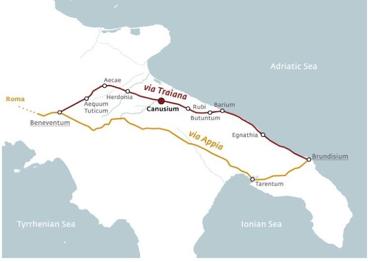
- Via Traiana (109 Marcus Ulpius Traianus, Trajan) alternative to the ancient Via Appia, from Benevento via Ascoli Satriano, Canosa di Puglia, Ruvo and Bitonto towards Bari (Adria), and as Via Traiana Costiera (coastal route) or as than Via Traiana Interna (inland), by Rutigliano and Conversano, then towards Brindisi.
- Via Traiana Calabra extension of Via Traiana, from Brindisi to Otranto.
- Via Tuscolana from Rome to Tusculum.
![]()